Metos Beta is now open for qualifying courses Learn about Metos Apply for access
Why Turflogic

Better data.
Better golf.

Golf course management has relied on observation for decades. Turflogic adds objective, continuous intelligence, finding problems before they surface.

Our approach
The Platform

One picture.
Complete clarity.

Every instrument Turflogic uses feeds a single outcome: an objective, continuously updated picture of your course’s health, benchmarked, archived, and actionable.

Open TurfScore
Featured Courses

Real courses.
Real data.

Every club in the Turflogic network is a live proof of concept, stress found early, interventions targeted, turf health trending upward.

Learn Why
The Platform
Featured Courses
Open TurfScore ↗ Talk to Us
Full-course contour lines, Audubon Country Club

Contour Maps

Drainage problems are
invisible until they damage.

A superintendent walks the course daily but can't see water movement. A 1% grade change redirects thousands of gallons across a green, hidden in fog or low light, revealing problems only when wet years arrive.

Detailed contour line overlay on golf course terrain

LiDAR and photogrammetry.
Hundreds of readings per metre.

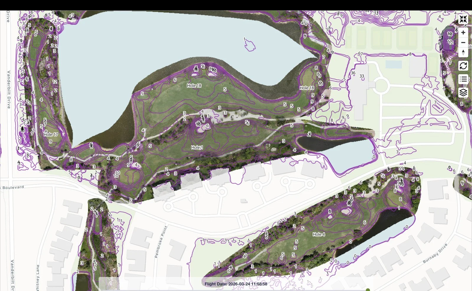
In one flight, Turflogic captures what traditional grading estimates take weeks to produce, with centimetre-level precision. Every elevation change, every pinch point where compaction concentrates—captured and queryable.

LiDAR Point Cloud
Centimetre accuracy
Laser scanning produces elevation readings at hundreds per square metre, capturing the actual turf surface, not an estimate. Sub-centimetre vertical precision on flat areas.
Photogrammetric Mesh
Visual surface
Photogrammetry creates a high-resolution 3D model of the turf surface, georeferenced and registered to the LiDAR data for complete spatial accuracy.
GIS-Ready Outputs
Engineering-grade datasets
Compatible with CAD, GIS platforms, and design tools. Contour lines, DEMs, shape files—all exportable and queryable.

Precision terrain
drives precision decisions.

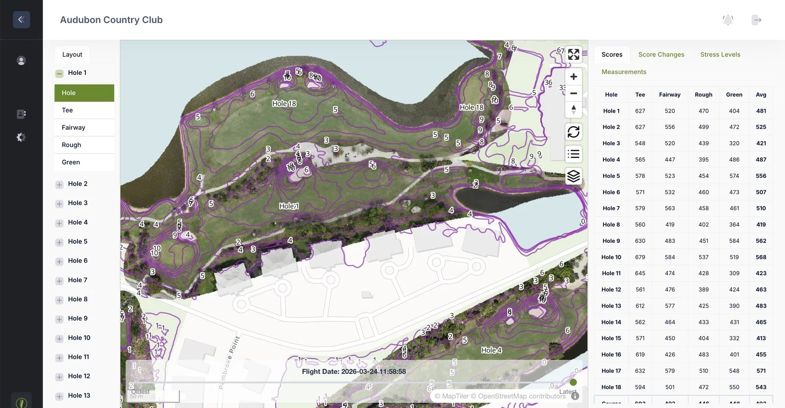
Contour data transforms renovation and maintenance planning. Overlay it with stress maps and irrigation zones to turn elevation into actionable decisions.

Water Flow
Overlay with stress maps
Confirm if moisture stress links to poor drainage or irrigation gaps. Add drainage tile or adjust coverage accordingly.
Renovation Verification
Pre- and post-grading baseline
Capture baseline terrain before work. Compare post-construction contours to verify grading execution, quantified.
Irrigation Design
Account for topography
Use contour data to optimize head placement and spacing. Design systems that match actual terrain, not assumptions.

Contours live in context
with every other layer.

Contour data lives permanently in the Turflogic platform, visible and queryable alongside every stress map, irrigation overlay, and TurfScore benchmark. Your onboarding flight captures the terrain once—you're never analyzing turf in isolation from the ground beneath it.

Single Coordinate System
Perfectly registered
Terrain, stress, irrigation data all captured in one flight, one system, one location.
Layer Toggle
Switch instantly
Toggle between contours, elevation heatmaps, flow arrows, and stress overlays in the same view.
Historical Archive
Track terrain changes
Contours remain available flight to flight. Build knowledge. Quantify changes with play and maintenance.

Terrain data that
lives in the platform.

Contour mapping is included in full Turflogic deployments. Talk to us about adding it to your course.

Request a Conversation
Turflogic AI Online
Hi there! I'm the Turflogic assistant. Ask me anything about our platform, drone technology, soil scanning, or turf management.